Sediment Runoff
Sand, silt and clay are a natural part of the Chesapeake Bay. But in excess amounts, sediment can cloud the waters of the Bay and its tributaries, harming underwater life.
Overview
Sediment is made up of loose particles of sand, silt and clay. It is a natural part of the Chesapeake Bay, created by the weathering of rocks and soil. In excess amounts, sediment can cloud the waters of the Bay and its tributaries, harming underwater grasses, fish and shellfish.
Where does sediment come from?
Sediment forms when rocks and soil weather and erode. Around 5.2 million tons of sediment enter the Chesapeake Bay in an average year.
There are two major sources of sediment: eroding land and stream banks—called watershed sources of sediment—and eroding shorelines and coasts—called tidal sources of sediment.
Watershed sources of sediment
Eroding land and stream banks are called watershed sources of sediment. Watershed erosion increases when land is cleared of vegetation to make way for agriculture and development. Scientists estimate that most of the sediment that flows into the Chesapeake Bay comes from watershed sources.
In the Bay watershed, river basins with the highest percentage of agricultural lands yield the highest amount of sediment each year. Basins with the highest percentage of forest cover, on the other hand, yield the lowest amount of sediment. On a per-acre basis, construction sites can produce the most sediment of all land uses—as much as 10 to 20 times that of agricultural lands.
Since the seventeenth century, watershed-wide changes in land use and land cover have disrupted the natural processes of erosion:
- During the eighteenth and nineteenth centuries, 70 to 80 percent of the watershed’s forest cover was removed to supply people with firewood and farmland. Cleared, exposed land is prone to erosion.
- Deforestation peaked in the late nineteenth century, and while reforestation did take place during the twentieth century, increased urbanization has continued to contribute to high erosion rates.
- Studies of sediment cores in the Bay and its tributaries show a four- to five-fold increase in sediment accumulation rates in some parts of the Bay since the 1800s.
Show image description
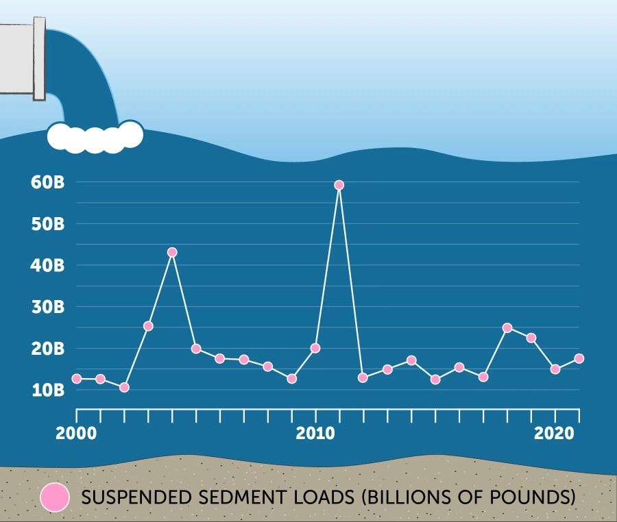
The line graph shows the span of time from 2000 to 2021 and phosphorus loads from 0 to 60 billion pounds. It begins in 2000 between 10 and 15 billion pounds and drops slightly in 2001 and 2002 before surging up to almost 25 billion in 2004 and almost 45 billion in 2004. It then drops to 20 billion and continues dropping to below 15 billion in 2009 before increasing again, to a huge peak of nearly 60 billion in 2011. It then drops to under 15 billion in 2012 and goes slightly lower and higher before rising to 25 billion in 2018. It decreases to around 15 billion in 2020, with a slight increase as the chart ends at 2021.
Tidal sources of sediment
Eroding shorelines and nearshore areas, as well as the resuspension of already-eroded sediments, are known as tidal sources of sediment. Tidal erosion increases when shoreline vegetation is removed and there are not enough bay grasses growing in the offshore shallows to lessen the force of waves against the shoreline.
The Bay’s shorelines have been slowly eroding for thousands of years, due to wave action and natural sea-level rise. Tidal erosion can help maintain the Bay’s complex ecosystem; beaches and tidal wetlands, which are created and replenished by erosion, provide habitat for countless critters, including blue crabs, herons and terrapins.
However, human development along the shoreline can have negative impacts on the natural processes of tidal erosion:
- Man-made, hardened shorelines—those lined with rocks, wood or concrete—can interfere with natural tidal erosion, blocking the formation of wetland habitat and starving beaches of new sediment.
- Hardened shorelines can also lead to “nearshore erosion,” during which waves erode the shallow area immediately in front of the man-made shore. This increases the amount of sediment that is suspended in the water.
- Between 1988 and 2000, more than 19 miles of Virginia tidal shoreline was hardened on average each year. In Maryland, more than 300 miles of tidal shoreline were hardened between 1978 and 1997.
Accelerated sea-level rise caused by climate change can also increase tidal erosion.
How does sediment harm the Chesapeake Bay?
Excess sediment is a leading factor in the Chesapeake Bay’s poor health.
Because of their small size, the particles of sand, silt and clay that we call “sediment” often float through the water rather than settling to the bottom, and can be carried long distances during rainstorms. When there are too many sediment particles suspended in the water, the water becomes cloudy and muddy-looking. Cloudy water does not allow sunlight to reach the plants that grow on the bottom of the Bay’s shallows. Without sunlight, these plants—including underwater grasses—die, which affects the young fish and shellfish that depend on them for shelter.
Excess sediment can also have harmful effects on the wider Bay and the people who use it:
- Nutrients and chemical contaminants can bind with sediment, spreading through the Bay and its waterways with particles of sand, silt and clay. Fish and shellfish that live and feed on or near contaminated sediment can become contaminated themselves, triggering fish consumption advisories in various portions of the watershed.
- Excess sediment can smother oysters and other bottom-dwelling species.
- Accumulating sediment can clog ports and channels, affecting commercial shipping and recreational boating.
A case study in sediment: the Conowingo Dam and Chesapeake Bay water quality
Each year, the Susquehanna River provides the Chesapeake Bay with one-quarter of its sediment loads. For decades, three large reservoirs that sit behind dams located along the lower portion of the river have held back some of the sediment pollution that would have otherwise entered the Bay. But recent studies have drawn attention to these reservoirs’ changing effectiveness as “pollution gates,” with special attention paid to the reservoir behind the Conowingo Hydroelectric Generating Station, or Conowingo Dam.
In 2012, the U.S. Geological Survey (USGS) reported that the reservoir behind the Conowingo Dam had lost its ability to trap sediment and attached nutrients over the long term.
In 2014, the Lower Susquehanna River Watershed Assessment (LSRWA) team released the results of its evaluation of sediment management options at the Conowingo Dam. It found:
- The reservoir behind the Conowingo Dam is trapping sediment in the short-term. Because the reservoir is essentially full, it is trapping smaller amounts of incoming sediment and, during large storms, sending more silt and attached nutrients over the dam and into the Bay more often.
- The nutrients that enter the river upstream and attach to particles of sediment are a bigger threat to water quality than sediment alone.
- The management and mitigation of nutrients and sediment upstream of the reservoir would be more beneficial to Bay health than attempting to manage sediment at the dam through dredging, bypassing or operational changes.
While the effects of the sediment that can scour from behind the dam essentially cease once it settles to the bottom of waterways, lowering both sediment and nutrient pollution upstream of the Conowingo Dam would benefit Bay health.
To learn more, visit Learn the Issues: Conowingo Dam.
What you can do
To lower sediment pollution, consider combating erosion on your property. Spread mulch over bare ground, or plant buffers of trees and shrubs to capture runoff and hold soil in place.