Small plastics are a big problem
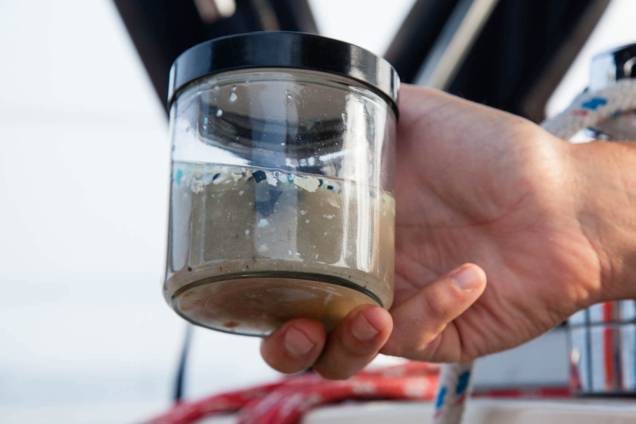
Plastic in the environment is a clear and known problem. We’ve all seen photos of the plastic bags suffocating birds and the plastic rings disfiguring turtle shells. Fast forward a few decades, and those bags and bottles in our waters have had time to start breaking down. Large becomes small, macro becomes micro, and the plastic acts like a tissue left in a pocket that goes through the wash. It disintegrates, floats, enters the cells of living creatures, gathers up chemicals and releases its own. We call this new pollutant microplastic, and the effects are catastrophic.
What threats do microplastics pose?
Microplastics are defined as plastic pieces under five millimeters in size. Primary microbeads—little bits of exfoliating plastic deliberately added to products like toothpastes and soap—were banned in 2015, but secondary microplastics continue to enter the environment as larger pieces of plastic break down.
Microplastics come from obvious sources like plastic soda bottles or packaging, but also from lesser-known plastic products. Our take-away coffee cups are coated in plastic; our polyester and other synthetic clothing is made with plastic. We create microfibers (microplastic from fabric) every time we wash these clothes, adding more and more pollution to our waters. These sharp-edged and variously-shaped fibers can cause even more damage in the environment than the smoothly rounded primary microbeads.
Size-wise, smaller and smaller does not mean safer. Very tiny microplastics called nanoplastics measure in at smaller than one micrometer. For reference, it takes one thousand micrometers to measure up to a single millimeter, and a single millimeter is about the size of a pin head. At this size, nanoplastics are small enough to cross the cellular membrane. Do they affect respiration? Gene expression? It is hard to say. Research into nanoplastics and their effects have only just begun. But take a deep breath—you probably just breathed in plastic.
Plastic production and disposal globally has increased 200-fold over the last 60 years. There is plastic on our land, in our waters and inside wildlife.
In the North Pacific, fish that live in the twilight zone (200 to 800 meters or approximately 650 to 2,600 feet down) consume between 12 thousand and 24 thousand tons of plastic each year. And plastics are not clean—thanks to the breakdown of all that trash, an estimated 190 tons of chemical additives released from the plastics mix annually into the ocean.
Up on land, more than 60% of all seabirds have ingested plastic, with that number expected to rise to 99% by the year 2050.

Concerned that a plastic soup in our waters could mean problems for the Chesapeake, the Chesapeake Bay Program Scientific and Technical Advisory Committee (STAC) reviewed studies and gathered experts for a 2019 workshop on microplastics. The resulting report was alarming.
To date, the U.S. Geological Survey has found microplastics in all samples taken at nontidal stations in the Chesapeake watershed. This means that microplastics are not only in our bay, they are all throughout our rivers and streams.
Disease and other contaminants
Plastic itself is a problem, but there is the additional danger of what it carries. Microplastics are "sticky"; they leach the chemicals they carry like slow-release capsules and pick up other chemicals along the way.
At the workshop, Dr. Susanne Brander of Oregon State University gave a talk on microplastics in fish. Her work focused on black seabass, an ocean fish that frequents the southern portion of the Bay. Like many other Chesapeake Bay fish, seabass eat a wide variety of prey and are themselves eaten by humans. Brander’s study found microplastics, and the chemicals that leach out of the plastic, present in the wild seabass. As we head up the food chain, humans eat these microplastics and chemicals, too.
To date, the U.S. Geological Survey has found microplastics in all samples taken at nontidal stations in the Chesapeake watershed.
This stickiness also spells trouble for our most celebrated habitats: shorelines and underwater grass beds. Microplastics will concentrate where they can settle, which means that these habitats are becoming microplastic hotspots.
Like a piece of tape is a magnet for dust in a room, microplastics pick up chemicals—and diseases. A recent study found that microplastics serve as foundations for all three species of Vibrio that cause disease in humans. If plastics are serving as carriers for Vibrio, they can help facilitate the movement of the disease from the open ocean to the Bay.
Oysters
The Bay’s favorite bivalve is also struggling with the tiny pollutants, as seen in the studies conducted by Christine Knauss of the University of Maryland Center for Environmental Science.
Microplastics in the water column float along in much the same way as algae, the oyster’s preferred food source. Knauss exposed oysters to water containing concentrations of microplastics that match the current pollution levels found in the wild. Over six days, the oysters that ate plastic significantly increased their algal clearance rates. Algal clearance rates relate to how much water the oysters are filtering, so at first glance this would sound like good news.
What it really means is stress. The oysters eating microplastics must clear more algae in order to get the same amount of nutrition as their clean-water brethren. Think of it like hyperventilating—you aren’t better at breathing by doing it faster; your system is stressed, and something is wrong.
Wastewater
Wastewater treatment plant upgrades are one of the great environmental success stories of the last decade. In 2016, plants met their goals for reducing nutrient pollution and doing their part to help clean up the Bay—but that doesn’t account for microplastics.
Treatment plants just weren’t designed to target microplastics. There are 516 major wastewater treatment plants in the Chesapeake Bay watershed. Studies noted in the report found that wastewater effluent (the treated water released from the plant) spits out four million microparticles per facility per day. That is a considerable amount of microplastic, but this still only considers the water that goes through a wastewater treatment plant. All throughout the watershed, there are urban and suburban storm drains funneling untreated, plastic-filled stormwater directly into the Bay and its rivers.
What can we do?
Thankfully, there are alternatives to plastics in the works. Bacteria already present in water naturally produce a biopolymer known as Polyhydroxyalkanoate (PHA). The bacteria use this biopolymer to store energy in much the same way that humans produce fat for energy storage, but humans can use this natural biopolymer as an alternative to plastic. Researchers at the Virginia Institute of Marine Science are experimenting with the biopolymer to try and discover some of these novel uses. Where microplastics are the dark harbingers of disease, there is some promising evidence that PHA can provide a level of immunity to pathogens.
At the close of the workshop that generated the microplastics report, STAC concluded that microplastics pose a serious threat and recommended forming a Plastic Pollution Action Team for further research and monitoring.
Above all, remember that large plastics become microplastics.
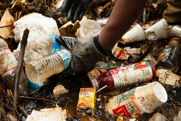
- Take control of your trash, and don’t let it become part of the environment. When fishing or enjoying time on the water, take your trash with you. On land, use trash cans and cut down on plastic containers.
- Plastic packaging from shipments and deliveries is a large contributor to plastic pollution. Where you can, skip the online order and shop local in-store.
- On a local scale, consider implementing trash traps and cutting down on single-use plastics.
- On a personal level, be aware of your plastic and refuse to add more. Refuse plastic bags at the grocery store and bring your own. Cut down on other throwaway plastic by carrying reusable water bottles and utensils.
- Reduce where you can and reuse where you can. When it is finally time to throw it out, try to repurpose first and eventually recycle.
Read the Scientific and Technical Advisory Committee’s report, “Microplastics in the Chesapeake Bay and its Watershed: State of the Knowledge, Data Gaps, and Relationship to Management Goals.”
Comments
This happened to be a very interesting article!
Echoing your article, French designer, I produced a series on ocean pollution based on photographs of plastic particles found on beaches around the world! To discover: https://1011-art.blogspot.com/p/ordre-du-monde.html
And I am starting a new series of drawings entitled Sea Line on pollution by industrial fishing, 47% of the 7th continent:https://1011-art.blogspot.com/p/laisse-de-mer.html
But also Anthropocene about the same topic: https://1011-art.blogspot.com/p/planche-encyclopedie.html
Draw to raise awareness!
Hello David, the five nontidal stations mentioned were discussed in depth in that particular study to emphasize that plastics are in rivers as well as the Bay itself, but plastic contamination is not exclusive to those five stations. 20 urban stations in the watershed were sampled for this study and found to have microplastics. There are 121 nontidal stations in total covering the watershed. The study is discussed on page 23 of this report https://www.chesapeake.org/stac/wp-content/uploads/2019/10/FINAL_STAC-Report_Microplastics-1.pdf, and all nontidal stations are shown on this map https://cbrim.er.usgs.gov/maps.html. Hope this helps!
I am a bit confused. How are data from only five nontidal stations, three of which are near metropolitan areas, being used to say microplastics are "all throughout" the Chesapeake Bay watershed? Thats not a great spatial distribution at all and hardly seems to really provide a truly representative picture of the full watershed. This article is definitely a wake up call on microplastics and presents the data in an easy to understand way, but I am not sure how widespread this is based on what has been stated.
Wow! Awesome! My kids will love this!
Good question! Yes, the tributaries that flow into the Bay have been sampled, as far up as New York state. These maps show the different tidal and nontidal sampling stations https://cbrim.er.usgs.gov/maps.html
The microplastic sampling has been focused on the Bay-- and it is very disconcerting!
I am curious if there has been any sampling in the tributaries which flow into the Bay? If so, how far up? E.g. has the Potomac at Cumberland been sampled?
Enjoyed reading this science article, It is an informative
and easily understood concept (if a bit alarming), everyone needs to know and be reminded, I have a heightened awareness of my world and plan to take more action whenever and wherever I can.
Thank you!
Your comment has been received. Before it can be published, the comment will be reviewed by our team to ensure it adheres with our rules of engagement.
Back to recent stories