SAV Monitoring Program
The Chesapeake Bay Program takes an integrated, three-tiered approach to monitoring Submerged Aquatic Vegetation
The Chesapeake Bay Program’s SAV monitoring effort employs a three-tiered approach to monitoring submerged aquatic vegetation (SAV) in the Bay. The integrated system includes aerial surveys, volunteer monitoring and sentinel sites.
Why we monitor SAV
SAV is a critical component of a healthy Chesapeake Bay ecosystem. It improves water quality by absorbing excess nutrients, reduces erosion by dampening wave energy, supports fish and shellfish by providing habitat and nursery grounds, and mitigates the impacts of climate change, among many other benefits. The Chesapeake Bay Program has a goal of restoring 185,000 acres of SAV throughout the Bay, a goal that is overseen by our SAV Workgroup. Monitoring the distribution, density and diversity of SAV in the Chesapeake Bay, along with several other habitat parameters, is the only way to determine whether management efforts are effective, detect issues of immediate concern, forecast emerging and potential issues and strategically guide SAV research.
Our approach to monitoring SAV
As the nation’s largest estuary, the Chesapeake Bay can be particularly difficult to monitor. To provide the best possible data on the abundance and health of SAV in the Bay, the Chesapeake Bay Program’s SAV monitoring effort includes three-tiers of hierarchical data collection: the Bay-wide Aerial Survey (Tier 1), the SAV Watchers Program (Tier 2) and the SAV Sentinel Site Program (Tier 3). The three-tiered approach allows us to not only estimate SAV acreage and density across the Bay, but also collect detailed habitat and water quality data while providing educational volunteer opportunities to communities across the watershed.
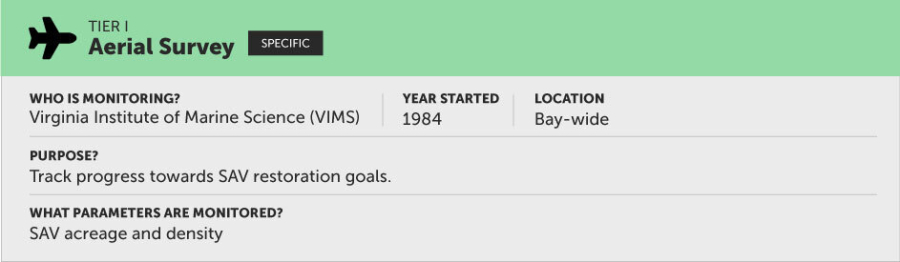
Tier I: Chesapeake Bay-wide Aerial Survey
Since 1984, the Chesapeake Bay Program has worked with the Virginia Institute of Marine Science (VIMS) to conduct an annual, Bay-wide aerial SAV survey. The data collected are used to report SAV acreage and density throughout the Bay and its tidal tributaries and track progress toward the 185,000-acre SAV goal.
Learn more about the Tier I approach
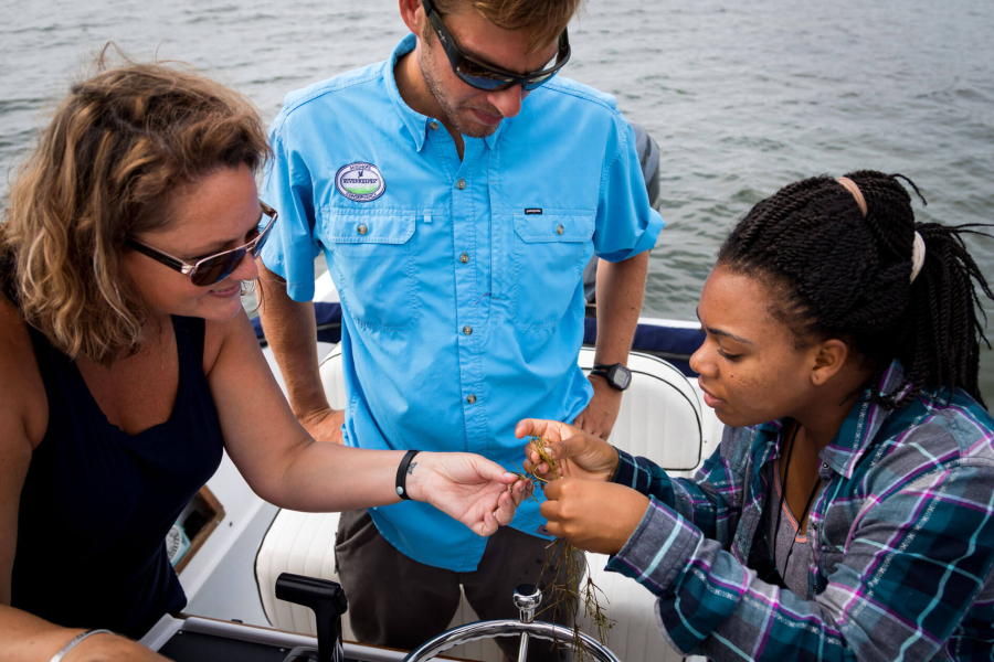
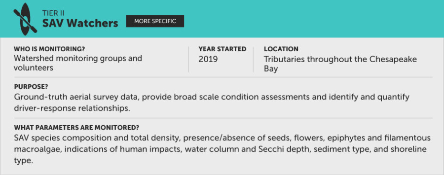
Tier II: Chesapeake Bay SAV Watchers
Volunteer scientists observe and report SAV habitat characteristics (e.g., species present, Secchi depth, sediment type) at sites throughout the Bay and its tributaries. These data are useful for a broad-scale condition assessment and for identifying and quantifying cause-effect relationships.
Learn more about the Tier II approach
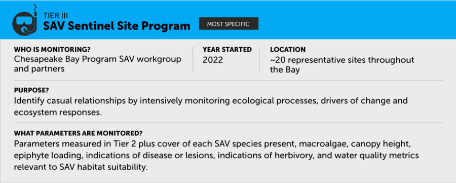
Tier III: Chesapeake Bay SAV Sentinel Site
A detailed, long-term SAV data collection effort at several representative locations throughout the Bay and its tidal tributaries. These data help identify causal relationships by monitoring drivers of change, ecosystem responses, and ecological processes.
The Bay-wide aerial SAV survey is the foundation for the Chesapeake Bay SAV Monitoring effort. The aerial survey is the most consistent large-scale, long-term SAV monitoring program in the world and its data are used widely by federal, state and local agencies, academic institutions, and other organizations for research, education, public communications and regulatory decision making. The higher tiers of SAV data collection add detail and strength to this long-standing program.
Learn more about the Tier III approach
The benefits of SAV monitoring
What we learn through monitoring SAV
Monitoring SAV provides the data and information necessary to manage and protect the Bay for future generations. The Bay-wide aerial survey, for example, maps SAV in each of the Bay’s rivers. If SAV expands in one river but contracts in another nearby, that tells us that a stressor unique to that river may be to blame. Likewise, data collected by volunteers involved in the SAV Watchers program provide more detailed information related to habitat and water quality. This data can help identify stressors in a specific river, such as an algae bloom or propeller scarring from boats. Data collected by the SAV Sentinel Site program provides an even more detailed look at the health of the grasses, including issues such as lesions caused by pathogens or an overabundance of light-blocking epiphytes.
How the Bay Program incorporates SAV monitoring
Historically, SAV monitoring efforts helped researchers set habitat requirements for SAV and those habitat requirements ultimately helped inform the Chesapeake Bay Total Maximum Daily Load (Bay TMDL). Habitat requirements are the conditions associated with a thriving SAV population, such as low levels of nitrogen, phosphorus, suspended sediments and chlorophyll a in the water column and good water clarity. More recently, using long-term SAV monitoring data, Bay scientists were able to empirically link nutrient management and SAV habitat restoration, demonstrating the success of the multi-state partnership approach the Chesapeake Bay Program takes to reducing nutrient pollution (Lefcheck et al. 2018). Specific studies and reports can be found on the SAV Workgroup page.
What would Bay scientists like to know?
The Chesapeake Bay Program SAV Workgroup maintains a list of science and research needs to help guide future project development. Many of these needs are related to SAV monitoring and include but are not limited to the following:
Habitat Requirements
Need: Determine the habitat requirements for recovering SAV beds and seedlings as opposed to those required by mature, stable SAV beds.
Reason: Our current SAV habitat requirements are based on the needs of mature, stable SAV beds.
Sea Level Rise
Need: Determine the impact of SLR and other climate change scenarios on our ability to reach segment-specific and Bay-wide SAV restoration targets.
Reason: Sea level rise (SLR) and other symptoms of climate change are predicted to heavily impact the Chesapeake Bay region.
Ruppia maritima Deds
Need: Determine the ecosystem services/co-benefits of Ruppia maritima beds compared to Zostera marina beds.
Reason: Ruppia maritima has already and will continue to replace Zostera marina in areas throughout the polyhaline portion of the Chesapeake Bay.
Climate Change
Need: Identify degree and likelihood of climate change impacts to freshwater and mesohaline SAV species.
Reason: Relatively little is known regarding the effects of climate change on freshwater and mesohaline species of SAV.
Blue Carbon Sequestration
Need: Identify fresh and brackish-water SAV species’ role in blue carbon budget. Quantify the ability of freshwater and mesohaline SAV species and habitats to sequester carbon.
Reason: The Chesapeake’s SAV beds sequester blue carbon released into the air.
Aquaculture
Need: Determine the impact of the expanding aquaculture industry on our ability to reach segment-specific and Bay-wide SAV restoration targets.
Reason: Aquaculture practices are expanding throughout the Chesapeake Bay.
Shallow Waters
Need: Determine impact of shallow water use conflicts on our ability to reach segment-specific and Bay-wide SAV restoration targets.
Reason: As SAV recovers, shallow water use conflicts are becoming more apparent.
Living Shorelines
Need: Examine whether living shorelines support long-term increases in SAV.
Reason: Living shorelines are becoming a more prevalent means of shoreline erosion control in the Chesapeake Bay