Eyes on the Bay
Restoration officials observe the Bay Program’s monitoring of the Chesapeake firsthand

August and September were very wet and rainy months in most parts of the Chesapeake Bay region. But on September 19, there was a break in the clouds, which was fortunate for those of us going on a water quality monitoring “cruise” in the northern portion of the Bay. Maryland Secretary of Natural Resources Mark Belton invited Environmental Protection Agency (EPA) Regional Administrator Cosmo Servidio, Water Division Director Cathy Libertz, and me to join him and his staff on their research vessel to observe their tidal Bay monitoring team in action.
The Department of Natural Resources (DNR) monitoring teams do water quality monitoring cruises on the Chesapeake Bay on a regular basis during the year. They take samples at numerous stations during three-day cruises beginning in the south at the mouth of the Bay and finishing up north where the Susquehanna River meets the tidal Bay.
We began the day by visiting one of DNR’s fixed monitoring stations where the team took various measurements including water temperature, salinity, dissolved oxygen, Ph, turbidity and chlorophyll a. They also took water samples to test for levels of nitrogen, phosphorus and sediment, which are the three pollutants all the Bay jurisdictions are working to reduce under the Chesapeake Bay Total Maximum Daily Load.
The team prepares all the samples for further testing and analyses at the University of Maryland’s Chesapeake Biological Laboratory. The results of this data analysis are then provided to the Chesapeake Bay Program’s monitoring partnership, which includes data from the other Bay jurisdictions, federal agencies and other partners
Monitoring the Bay and its tributaries allows the Bay Program to detect changes that take place, improve our collective understanding of the Bay ecosystem, and reveal trends over time that provide valuable information to Bay policy makers and program managers.
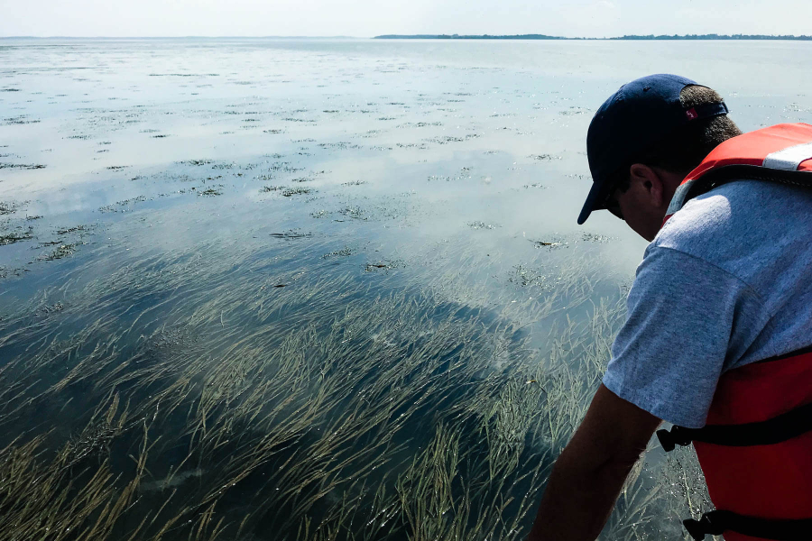
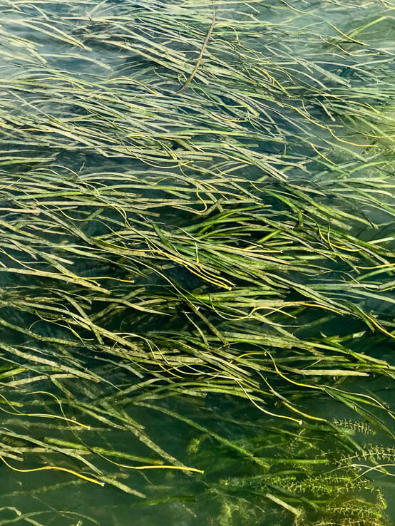
On the second leg of our cruise, we ventured out into an area in the upper Bay known as the Susquehanna Flats. This is the longest contiguous bed of underwater grasses, or submerged aquatic vegetation (SAV), in the Chesapeake Bay, spanning approximately 10 square miles in the Bay near the mouth of the Susquehanna River.
Underwater grasses are important because they offer food to invertebrates and migratory waterfowl, shelter young fish and crabs, and keep the water healthy by absorbing excess nutrients, trapping suspended sediment and slowing shoreline erosion.

Despite the sunny weather that day, our hosts were concerned that we wouldn’t be able to see much of the grass beds due to the unusually high amounts of rain we have had this summer in the Bay region. In fact, according to the National Oceanic and Atmospheric Administration, since June 1, more than twice the normal amount of rainfall has fallen over a broad swath from Washington, D.C., up through Maryland and central Pennsylvania. As a result, river flows into the Bay are higher as well, with U.S. Geological Survey measurements showing that freshwater flows into the Bay this August were the highest ever recorded for that month by a wide margin.
These high flows forced the opening of many of the flood gates of the Conowingo Dam, which sits on the Susquehanna River. The resulting release of debris and sediment and nutrients from behind the dam had made the Upper Bay where the Flats are located quite murky, with high levels of turbidity.
Despite those conditions, when DNR steered our boat into the shallow waters of the grass beds, we were still able to see many of the dozen or more species of underwater grasses that live in the Bay. While cloudier than usual, we still could pick out large stands of widgeon grass and wild celery, with some hydrilla present also.
I really found it to be quite awe-inspiring to be out in the middle of almost 10,000 acres of underwater grasses. And while Administrator Servidio has traveled extensively around the Bay region on farm tours and viewing best management practices and restoration projects in both urban and rural settings, this was the first time he was out on the Chesapeake Bay itself.
“I am impressed with the robustness of the water quality monitoring program and what Secretary Belton and his staff have shown us today,” he remarked on the trip. “Seeing the extent of underwater grasses here is truly amazing and I hope to make it out here again soon.”
It will indeed be interesting to see next time what impact the record rainfalls and associated nutrient and sediment load increases will have on Bay water quality and the abundance of the underwater grasses here and elsewhere.
As is typical of the partnership, we worked together this summer as Maryland DNR did additional monitoring cruises following the storm events and EPA paid for some related additional lab analysis from the samples DNR collected. We will see if the resiliency we are trying to build by putting best management practices on the land will help to minimize any potentially adverse impacts to water quality, underwater grass abundance, fisheries and habitat. The Bay Program’s scientists will undoubtedly be making comparisons to Hurricane Irene and Tropical Storm Lee in 2011 and other similar high-flow events to see if the resilience of the Bay ecosystem is improving as much as we have been working towards… and hoping for.

Comments
There are no comments.
Thank you!
Your comment has been received. Before it can be published, the comment will be reviewed by our team to ensure it adheres with our rules of engagement.
Back to recent stories