Updated: Sandy brings rain, flooding to Chesapeake Bay
From spilled sewage to shellfish bans, we are tracking the weather's effects on the watershed.
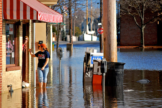
UPDATED: Superstorm Sandy brought rain, wind and flooding to the mid-Atlantic coast. But how has the storm affected the Chesapeake Bay? Take a look at the headlines below for the latest news on the environmental impacts of this damaging storm.
Sandy May Leave Toxic Legacy
Discovery News 11/05/2012
Hurricane Sandy has little effect on Bay
The (Easton, Md.) Star Democrat 11/05/2012
Coastal cities seek protections against superstorms
The Washington Post 11/04/2012
Gushing Susquehanna Called a Bigger Threat to Bay Pollution than Local Runoff
Southern Maryland Online 11/04/2012
Sandy might not harm Bay
The (Annapolis, Md.) Capital 11/04/2012
Sandy Environmental Toll: Polluted Rivers, Lost Seabirds
International Business Times 11/02/2012
Sandy's path, derecho eased wind damage in region
Southern Maryland News 11/02/2012
Raw sewage spills into Mattawoman Creek
Southern Maryland News 11/02/2012
Researchers Gauging Sandy's Impact on Chesapeake
Associated Press 11/01/2012
Beach Repairs After Sandy May Cost $8 Million a Mile
Bloomberg News 11/01/2012
In the wake of Sandy, Tangier makes its case for help
The Richmond (Va.) Times-Dispatch 11/01/2012
Sandy's Impact on Chesapeake Bay Less Than Expected
Patch.com (Edgewater-Davidsonville, Md.) 11/01/2012
Eastern Shore resilient, state will help in recovery, McDonnell says
The Richmond (Va.) Times-Dispatch 10/31/2012
Some Va. waters to be opened to shellfish harvesting
The (Hampton Roads) Virginian-Pilot 10/31/2012
Civil Air Patrol begins coastline damage assessment
The (Easton, Md.) Star Democrat 10/31/2012
Havre de Grace Not Worried About Flooding from Conowingo Dam
Patch.com (Havre de Grace, Md.) 10/31/2012
Power restored to Maryland water treatment plant
WTOP (Washington, D.C.) 103.5 FM 10/31/2012
Storm triggers big Howard sewage spill
B'More Green 10/30/2012
Sewage spilled into waterways from Virginia to New England
United Press International 10/30/2012
After the Storm: Cecil County Recovers but Bay, Susquehanna Still a Worry
The Cecil (Md.) Times 10/30/2012
Virginia portions of the Chesapeake Bay closed to shellfish harvesting due to flooding, rain
Associated Press 10/29/2012
Hurricane Sandy poses environmental threat to Chesapeake Bay
The Washington Post 10/27/2012
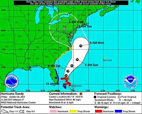
October 26, 2012 -- Hurricane Sandy could make landfall along the mid-Atlantic shoreline, raising concern over potential wind, rain, inland and coastal flooding and erosion in the Chesapeake Bay watershed.

Image courtesy National Hurricane Center
At the time of this post, the latest model simulation from the National Hurricane Center shows the storm hitting the mid-Atlantic region early next week.
But an exact forecast is hard to make. According to the National Oceanic and Atmospheric Administration (NOAA), the storm’s large size, unusual pattern as it interacts with an incoming cold-weather storm and timing to coincide with the full moon’s higher-than-normal tides make it difficult to predict its precise path and the resulting consequences it could have for the region.

Under certain conditions, the storm could create problems for the Bay. Excess rainfall in the watershed could increase the flow of polluted stormwater into rivers and streams and lead to inland flooding. A spike in Pennsylvania rainfall could boost the flow of the Susquehanna River and push sediment and debris into the Upper Bay, clouding the water and impairing marine life habitat. Strong winds could lead to strong waves, increasing erosion along beaches and shorelines.
When storms like this one enter the Bay ecosystem, the Chesapeake Bay Program’s network of scientists and experts monitor the storm’s effects on waters, habitats and resources.
While large storms can pose a challenge for the Bay, some regions have shown resilience to severe weather. After Tropical Storm Lee, for instance, scientists noticed that despite a decline in underwater grasses overall, grass beds in the Susquehanna Flats remained intact; widgeon grass beds grew, fueled by an influx of freshwater; and new grass beds were found in the James River.
The National Hurricane Center’s forecast track is updated every three hours. NOAA encourages citizens to check national and local weather forecasts often to prepare for the oncoming storm.
Bay conditions can be monitored at any time through the Chesapeake Bay Interpretive Buoy System.
Learn more about preparing for a storm like Sandy.

Comments
There are no comments.
Thank you!
Your comment has been received. Before it can be published, the comment will be reviewed by our team to ensure it adheres with our rules of engagement.
Back to recent stories